
FAQ
In most cases, this happens because your account has not been activated yet.
After signing up, Panoee automatically sends an activation email to the email address you registered with. You must activate your account before you can log in.
Please follow these steps:
-
Check your inbox for the activation email from Panoee.
-
If you do not see it, check your Spam / Junk folder, as the email may be filtered there.
-
Open the email and click the activation link to complete your registration.
If you still cannot find the activation email, please contact us via live chat and provide your registered email address. Our team can manually activate your account for you.
Yes. Panoee offers a free plan that you can use indefinitely, allowing you to create and publish virtual tours without any upfront cost.
You can build and manage multiple projects on the free plan, making it suitable for getting started or running basic virtual tour workflows.
However, the free plan includes a storage limit of 3GB. Once this limit is reached, you will need to purchase additional storage to continue uploading new content. Extra storage is available at a pay-as-you-go rate starting from $0.12 per GB, allowing you to scale usage flexibly based on your needs.
If you require more advanced features, higher limits, or professional usage, you can upgrade to a paid plan at any time.
Yes. Once your virtual tour is published, it will remain accessible and available online indefinitely.
Your tour will only become unavailable in the following cases:
-
You delete the project
-
You unpublish the tour
-
You deactivate your account
Otherwise, there is no automatic expiration or time-based limitation applied to published tours.
Are there any limitations that could affect availability?
The primary limitation is storage capacity.
By default, each account includes 3GB of storage. If your usage exceeds this limit, you can continue operating normally by purchasing additional storage at a flexible rate of $0.12 per GB.
There are no restrictions on number of views, traffic, or time duration that would cause your tour to be disabled.
Will my tour become unavailable if I am using a free or trial plan?
No. Once a tour is published, it will continue to remain accessible, even if you are using the free plan or after your trial ends.
Your account may lose access to certain premium features, but existing published tours will not be taken offline unless you manually take action (delete, unpublish, or deactivate).
Panoee is deployed and operated on Amazon Web Services (AWS), with infrastructure primarily located in North America. This setup ensures strong global connectivity and reliable service availability.
The platform is built with an auto-scaling architecture, allowing it to handle high volumes of traffic and concurrent users while maintaining stable performance.
To deliver fast loading speeds worldwide, Panoee uses 100% CDN delivery via CloudFront, ensuring that virtual tours and media assets are served from edge locations closest to your users.
All original panorama files are securely stored on AWS S3, following high-standard backup and durability mechanisms. Additionally, all media assets are logically isolated between users, ensuring strict data separation and security.
Panoee follows modern cloud security best practices to ensure that your data remains safe, accessible, and reliable at all times.
Private Hosting / On-Premise Deployment
If you require private hosting or on-premise deployment, this is available under a customized implementation model.
In such cases, the solution is delivered as a tailor-made (customized outsourcing) project, depending on your infrastructure and business requirements. Typically, this requires at least an Enterprise subscription or a dedicated agreement.
For consultation, please contact: neo@panoee.com
At the moment, Panoee does not provide a public API. However, API capabilities are already planned and will be introduced in the near future as part of the platform roadmap.
If your use case requires API integration today, this is still possible through a custom implementation. In such cases, we typically evaluate the project as a customized solution, where specific API endpoints and workflows are tailored to your requirements.
To proceed with this approach, you will need to subscribe to the Enterprise plan or contact our team directly for consultation. Please reach out via email at neo@panoee.com to discuss your use case and integration scope.
Yes. You have full flexibility when using exported tours.
You can either:
-
Embed via iframe into your existing website, or
-
Host it directly and access via your own domain
You are in complete control of hosting, domain configuration, and access setup, without any dependency on Panoee infrastructure.
Currently, this is not supported.
Exported projects are designed for external hosting and independent usage, and cannot be re-imported back into the Panoee editor.
No. Exported projects are static snapshots at the time of export.
If you make changes later in Panoee (e.g., editing hotspots, updating scenes), you will need to export the project again to get the updated version.
However, once the export feature is activated for a project, you can export unlimited times without additional cost.
Yes. The exported tour behaves exactly like the public version hosted on Panoee.
This means it is fully responsive on mobile devices and also supports VR viewing, providing the same immersive experience across devices without additional configuration.
The export feature is project-based. This means when you pay to activate export, it is applied only to the specific project you selected.
Once unlocked, you can export that project unlimited times without any additional cost. However, this does not automatically unlock export for other projects in your account.
If you need export functionality across multiple projects, you will need to activate it separately for each project, or consider upgrading to a plan that better fits your usage needs.
The export size depends entirely on your project’s content, including:
-
Number of 360 scenes
-
Number of images, videos, and media assets
In practice, export packages can range from tens of megabytes to several gigabytes.
This also directly impacts the export processing time — larger projects will require more time to generate the final package.
The export package includes all necessary static assets required to run your virtual tour independently. This typically consists of HTML, CSS, JavaScript, images, and other media files.
Once exported, you can host the tour on your own server or any hosting provider, without relying on Panoee’s infrastructure. The hosting process is straightforward and compatible with most standard web hosting environments.
Yes. Panoee fully supports drone-based 360 panoramas, as long as the final output is in equirectangular 2:1 format.
Popular compatible drone brands include:
-
DJI (Mavic series, Air series, Mini series, Inspire…)
-
Autel Robotics (EVO series)
-
Parrot (Anafi series)
-
Skydio
Most modern drones support panoramic shooting modes or allow manual stitching workflows, which can then be uploaded directly to Panoee.
Yes. While Panoee maintains a consistent global pricing structure, we regularly run promotion campaigns that help make the platform more accessible for independent creators and different markets.
You can access all current promotions here:
👉 https://studio.panoee.net/dashboard/promotions
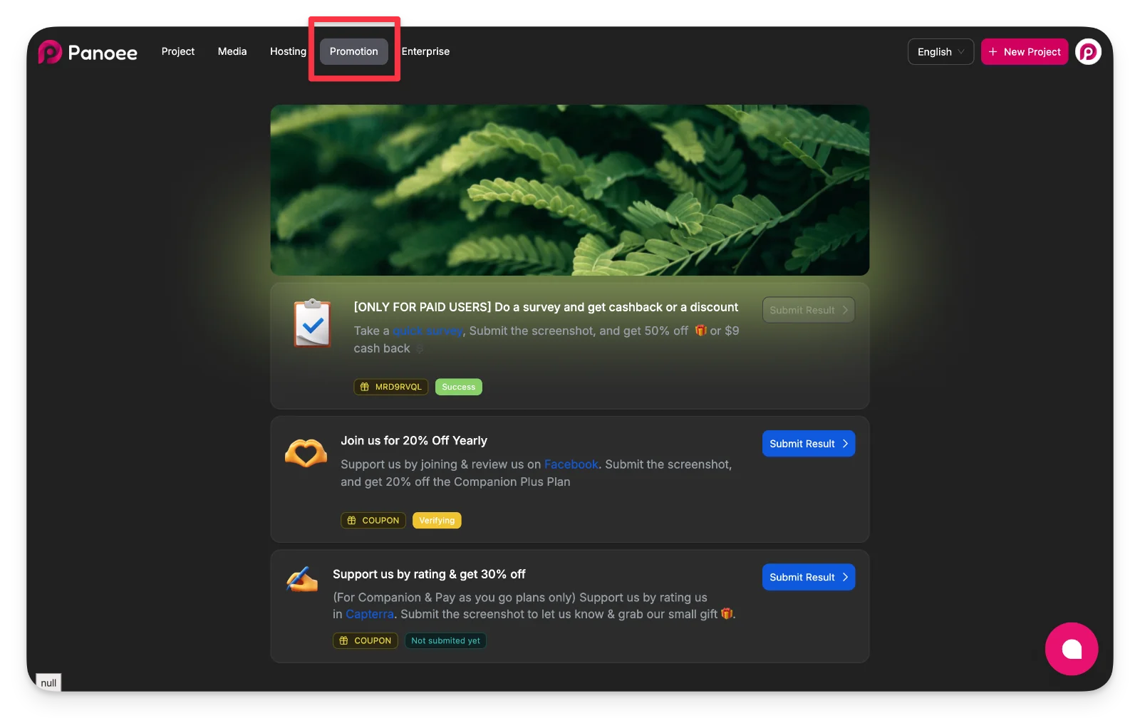
On this page, you will find various ongoing campaigns (e.g., surveys, reviews, or partner activities) that can provide discounts or cashback offers.
For new annual subscriptions, you can typically receive up to 20% off, depending on the active promotion at the time.
These promotions are designed to provide flexible ways to reduce costs without requiring regional pricing differences.
Currently, Panoee does not provide built-in tools for horizon correction.
You should correct alignment during post-processing using dedicated tools such as:
-
PTGui
-
Hugin
-
Kolor Autopano (legacy but still used in some workflows)
These tools allow precise control over leveling and stitching before exporting the final 360 image.
How can I handle nadir (tripod removal) efficiently?
There are two common approaches:
1. Manual editing (traditional method)
-
Use tools like Photoshop or other graphic editors
-
Clone, patch, or replace the tripod area manually
2. Automatic fix with Panoee (recommended)
-
Use the Auto Nadir Fix feature directly inside the editor
-
The system detects the nadir area and applies AI-based correction automatically
-
Learn more here https://document.panoee.com/docs/auto-nadir-fix
👉 This is the fastest and most efficient method for most use cases
Panoee does not require a specific camera model. The only requirement is that your input must be a 360° equirectangular image with a 2:1 ratio (standard format for virtual tours).
There are two common ways to create this type of image:
Option 1: Use a 360 Camera (Recommended)
This is the simplest and fastest method. These cameras automatically capture and generate ready-to-use 360 images.
Popular 360 camera brands include:
-
Ricoh Theta (Z1, X, SC2…)
-
Insta360 (One X2, X3, X4, One RS 1-Inch 360…)
-
Trisio (Lite 2, Pro…)
-
GoPro Max
-
Kandao (Qoocam series)
-
Labpano (Pilot series)
-
Samsung Gear 360
-
Xiaomi Mi Sphere
-
Vuze (Humaneyes)
These devices typically export images already in the correct equirectangular 2:1 format, ready to upload to Panoee.
Option 2: DSLR / Mirrorless Workflow (Professional Quality)
This method provides higher image quality but requires more setup and processing.
Equipment setup:
-
Camera: Canon, Nikon, Sony, Fujifilm, Panasonic…
-
Lens: Fisheye or ultra-wide lens
-
Panoramic tripod head:
-
Nodal Ninja
-
Manfrotto
-
Sirui
-
Neewer
-
Benro
-
Workflow:
-
Capture multiple photos covering all directions
-
Use stitching software such as PTGui (or alternatives like Autopano, Hugin)
-
Export the final image as a 360° equirectangular (2:1 ratio)
Which option should I choose?
-
360 Camera → faster, easier, ideal for real estate, volume work
-
DSLR Workflow → higher quality, better control, suitable for premium projects
Both methods are fully compatible with Panoee as long as the final output meets the equirectangular 2:1 requirement.
Panoee follows the capabilities of the krpano engine. The most commonly supported formats include:
-
JPG / JPEG (recommended for performance and compression)
-
PNG (supports transparency, larger size)
-
TIFF (high-quality source, typically used before optimization)
For best results, JPG is generally preferred for production tours due to its balance between quality and file size.
Panoee is built on the krpano rendering engine, which supports multi-resolution (multi-res) tiling. This means your panorama is automatically processed into multiple resolution layers and small tiles.
In practice:
-
Large images (even gigapixel panoramas) are fully supported
-
Only the necessary tiles are loaded based on the user’s view and zoom level
-
Users always get fast loading and smooth interaction, regardless of original image size
As a result, higher resolution improves visual quality without negatively impacting performance, as long as the image is properly formatted.
This issue usually occurs when your panorama or media files have been archived due to inactivity.
If a project has not received traffic for a period of time, its assets may be automatically moved to archival storage (AWS S3 Glacier) to optimize system performance and storage costs. As a result, those files are temporarily unavailable for immediate access, which leads to loading errors in the tour.
How can I fix this issue?
To resolve this, you need to restore (recover) the archived assets:
-
Go to your Project Editor → Settings → System
-
Find the Restore Images option and trigger the recovery process
Alternatively, you can contact us via Live Chat and provide your account email. Our team can assist with manual recovery if needed.
How long does recovery take?
The recovery process typically takes a few hours, depending on:
-
Total file size
-
Number of assets
-
Storage retrieval conditions
Once completed, your virtual tour will function normally again.